Using the functions of an Atis-Cloud Virtual Tour
Virtual tours have evolved considerably to offer immersive and interactive experiences. At 3D Scan Bat, we strive to provide our customers with complete solutions for an in-depth understanding of their projects. In addition to our 3D BIM models and architectural drawings, we also offer Atis-Cloud virtual tours. This cutting-edge technology allows our customers to explore their spaces in immersive detail. In this article, we'll explore in detail the key functions of these Atis-Cloud virtual toursThe result is a new way of viewing and presenting projects, easily accessible via a simple HTTPS link. Find out how this innovation can improve your project viewing and presentation experience.
The 3D virtual tours are revolutionising the way in which building, architecture and property professionals communicate and analyse their projects. Thanks to Atis-Cloud, 3D Scan Bat offers total immersion in your 3D surveys, with advanced functionalities that transform each scan into a genuine analysis and decision-making tool.
Atis-Cloud clipping box, orthoimage and zone export
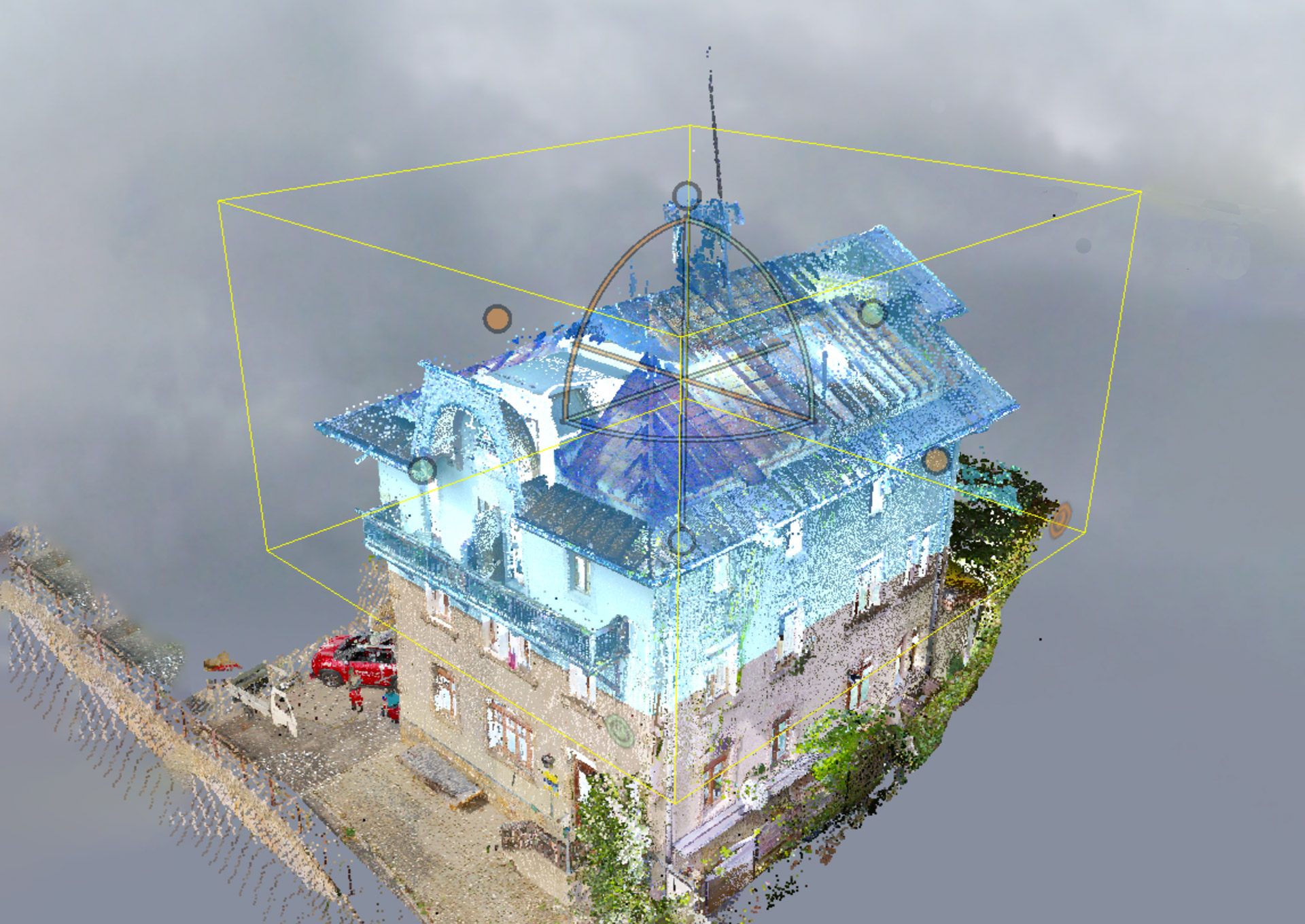
Atis-Cloud offers a remarkable feature called the 'Clipping Box', which allows users to define an area of interest to specifically display points inside or outside that area.
This function is particularly useful when exploring complex spaces where you want to highlight specific elements for export.
It can also be used to create orthoimages that can be exported. By defining a clipping box, you can refine your virtual tour and direct your visitors' attention to important details.
Whether you want to highlight architectural features, industrial equipment or any other element, the Atis-Cloud Clipping Box offers great flexibility.
To find out more about the features - Atis-Cloud clipping box, orthoimage and zone export - click on the links below
Create a cutting plan on Atis-Cloud
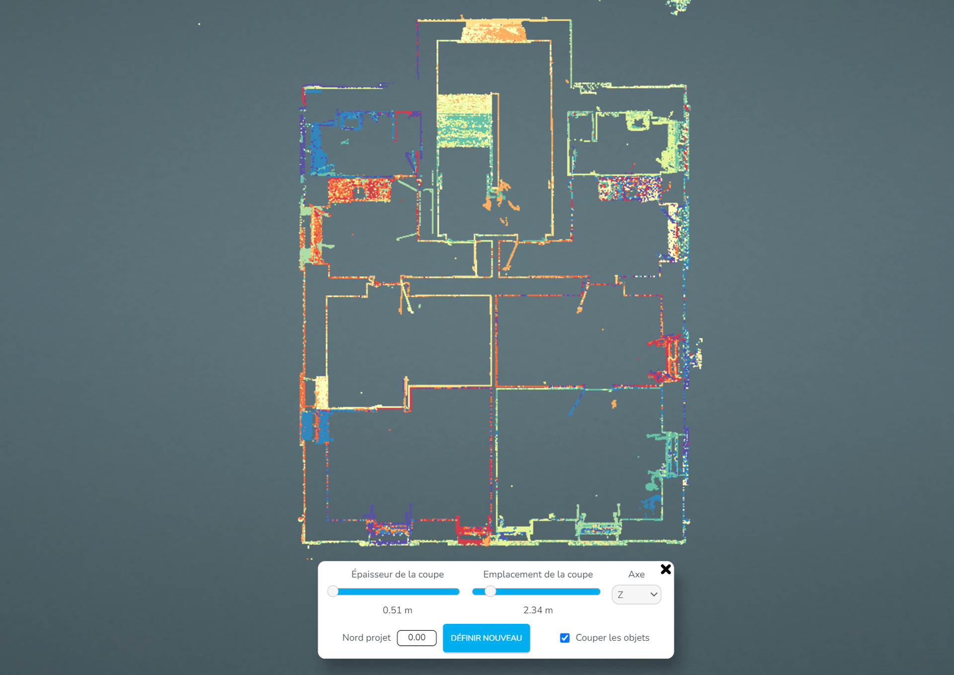
Atis Cloud offers the powerful Cut Plane feature, which allows users to view only a specific section of a point cloud.
This feature is particularly useful when you want to examine a specific part of your 3D virtual space in detail without being overwhelmed by the entire point cloud.
By creating a section plan, you can virtually cut out your virtual tour and focus on a precise area for in-depth analysis.
The Atis-Cloud cutting plan tool saves you time and maximises your efficiency. This tool can only be used to visualise the cross-section, so make sure you have an orthoimage before exporting.
To find out more about using this feature and how to create customised cutting plans, visit the dedicated page on the Atis-Cloud website. here.
Atis-Cloud has become a strategic tool for renovation, heritage and new-build professionals, enabling them not only to visualise measurements but also to extract reliable technical data. The accuracy of the measurements, the ability to create orthoimages or sectional plans at the click of a button, and the seamless integration into a BIM process make this platform an ally in saving time, limiting errors and improving remote collaboration. What's more, its compatibility with the main trade formats ensures continuity between field capture and the design office.
Easy sharing of the Atis Cloud virtual tour with a simple HTTPS link
One of the most user-friendly features of Atis-Cloud is the ease with which you can share your virtual tours. Once your virtual tour has been created and customised to your requirements, we'll send you a unique HTTPS link for that tour.
This link can be easily copied and shared with your customers, colleagues, friends or anyone else who wants to explore your virtual space.
With this method of sharing, you can reach a global audience in just a few clicks, without the need for complex downloads or installations.
The HTTPS link also guarantees the security of your visitors, as it is protected by an SSL certificate, ensuring the confidentiality of the data exchanged.
You can also integrate this link into your website, emails or social media for maximum visibility.
This simple and secure sharing function makes Atis-Cloud an ideal choice for those who want to present their virtual spaces transparently and efficiently.
Le HTTPS link is available for a maximum of one year and can be renewed
Measurement tool directly on the Atis-Cloud virtual tour
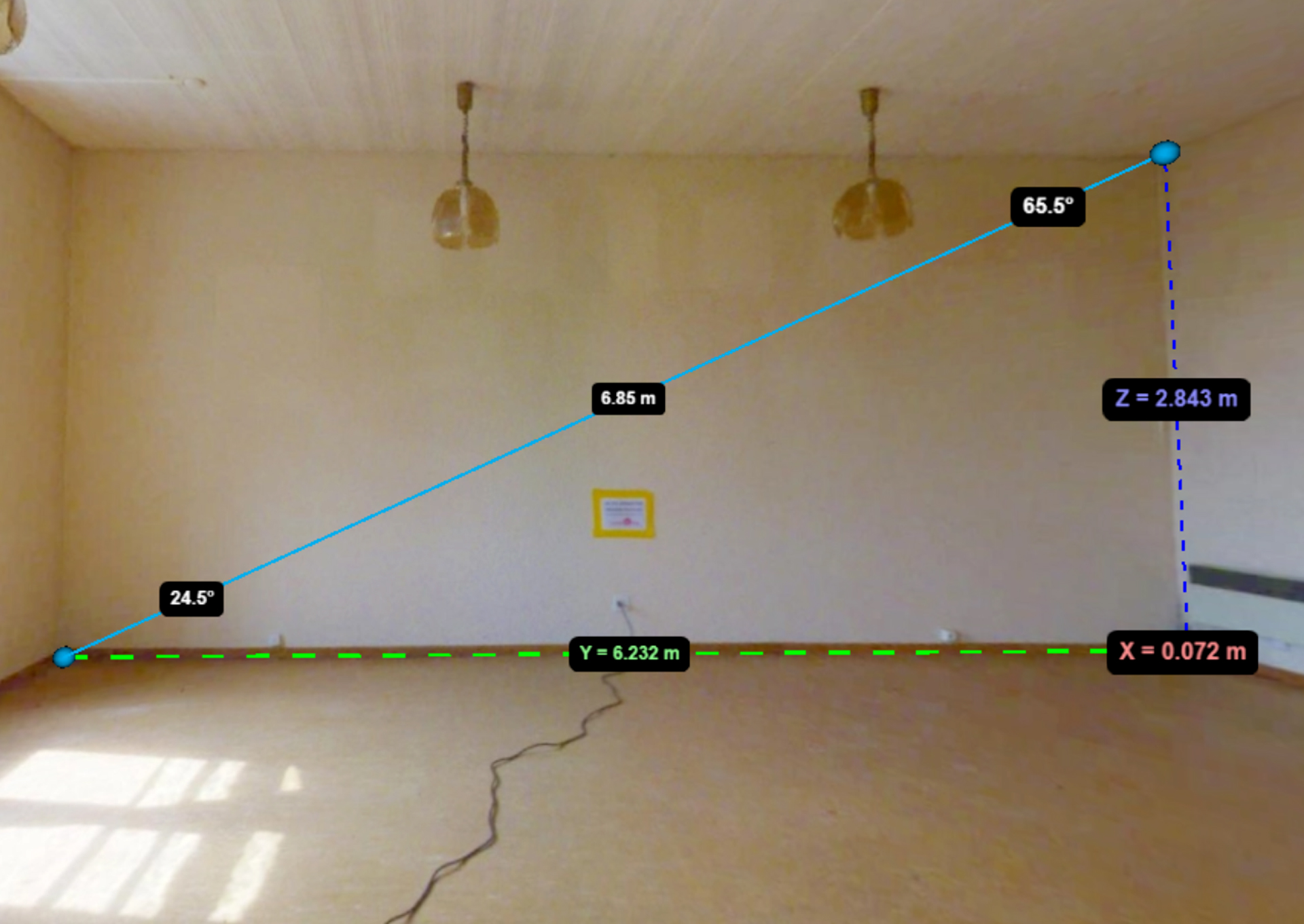
One of the outstanding features of Atis-Cloud is its powerful measurement tool, which allows users to make precise measurements directly in their virtual tours. Whether you need to calculate distances, angles, point coordinates, areas or volumes, Atis-Cloud gives you the tools you need to do it with ease. Whether you work in real estate, construction, architecture or any other field requiring precise measurements, this tool will be of great use to you. To find out more about how to use this feature and what it can do for you, visit the dedicated page on the Atis-Cloud website. here.
Thanks to this tool, architects, engineers and technicians can quickly validate hypotheses, adjust plans and anticipate structural inconsistencies. Interoperability with CAD software enables direct integration into BIM workflows, optimising collaboration between the various project participants.
This intuitive tool integrates perfectly with collaborative workflows. It saves project teams time when analysing and validating data. Measurements taken in the interface can be saved and exported, making it easy to share precise information with partners or customers. What's more, the immersive 3D environment reduces the risk of misinterpretation, and reinforces the reliability of technical decisions.
Atis-Cloud Height Profile
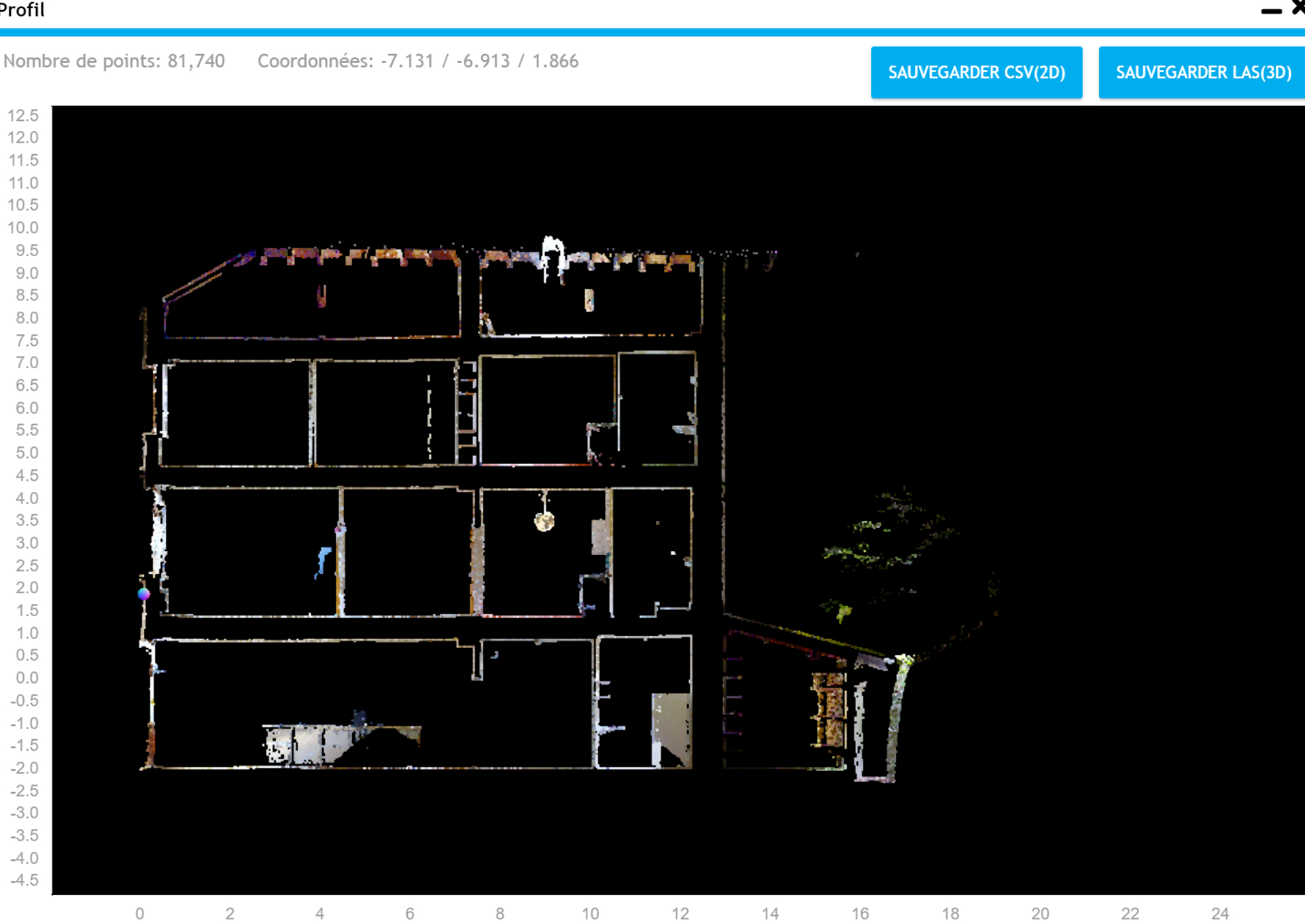
Atis Cloud offers advanced height profiling functionality, allowing users to accurately visualise height variations across their 3D point cloud. This functionality is essential in many sectors. With Atis Cloud, you can not only generate detailed height profiles, but also export all associated point data as CSV files for 2D or LAS files for 3D. This export capability gives you maximum flexibility to process and analyse your virtual tour data according to your specific needs. To find out how to create height profiles and use this functionality for in-depth analysis, visit the dedicated page on the Atis-Cloud website. here.
Improving the visual quality of the point cloud
For an optimal viewing experience, Atis-Cloud offers a range of features to enhance the appearance of the point cloud.
The LED lighting feature adds an extra dimension to your virtual tours by subtly illuminating key points in the environment, creating an immersive atmosphere. What's more, Atis-Cloud can display points in high resolution, providing exceptional clarity of detail.
Just as importantly, you can adjust the size of the dots for a personalised experience. Whether you want to highlight specific elements or get a more general overview, this feature adapts to your needs.
To see these visual improvements in action, watch our video herewho will guide you through these features and show you how to apply them for an exceptional immersive experience.
At 3D Scan Bat, we are integrating Atis-Cloud virtual tours into a global approach to intelligent surveying. In the future, these tools will go even further: dynamic digital twins, real-time interaction with connected objects, flow simulation or usage scenarios, etc. The virtual visit will no longer be just a visual medium, but a "tool" that can be used in a variety of ways. a real dashboard for the building. That's why we support our customers as they build their skills around these technologies, by providing them with usable, scalable deliverables. Contact us to turn your reports into tangible value.


 3D Scan Bat